Maps
 The nineteenth-century French Canadians were very aware of the history of New France and the area south of the Great
Lakes. New France was established during French exploration in 1543.
The nineteenth-century French Canadians were very aware of the history of New France and the area south of the Great
Lakes. New France was established during French exploration in 1543.
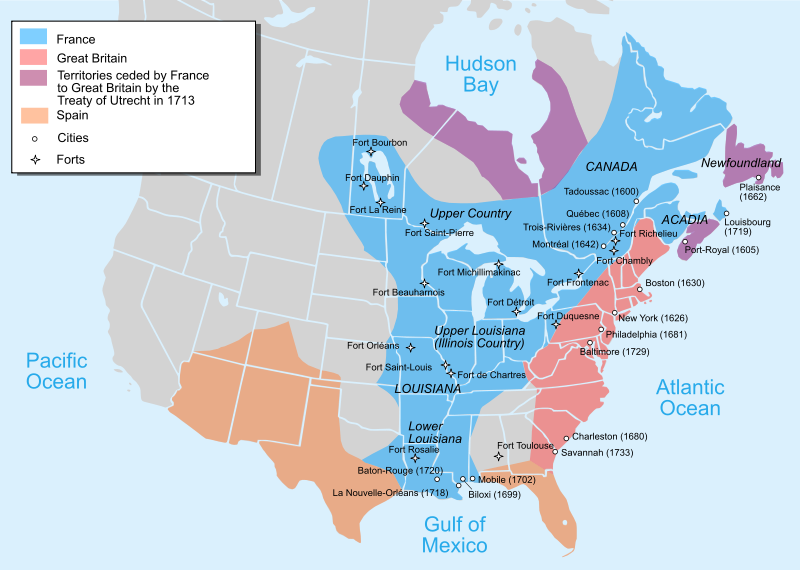
In 1717, the French crown detached the Illinois country from the Canadian part of New France and placed the area under the Louisiana colony’s jurisdiction. Louisiana, named after King Louis XIV, remained under French control from 1682-1763 and 1800-03. Napoleon Bonaparte (1799-1815) decided to sell Louisiana to the United States in 1803.
The French Canadians were very familiar with the explorations of the Kankakee River by Rene-Robert Cavelier Sieur de la Salle (1643-87). In La Salle’s quest to explore the rivers of the French colony, New France, that flowed into the Mississippi, he and thirty-three men made a portage from the St. Joseph River to a marshy river’s headwaters—in northwest Indiana today. The party continued paddling into the “Great West” with eight canoes and eventually completed the journey from Montreal to the mouth of the Mississippi.
La Salle named the river between the St. Joseph and Illinois Rivers the Seignelay in honor of colonial minister of France. The name was later changed to Theakiki and is now called the Kankakee (Johnson-Bourbonnais, 9). The Potawatomi called the land adjacent to the river “Te-yar-ac-ke” (“wonderful land”). The word “Ky-an-ke-ke” evolved. Some Indian tribes called the land “Te-ok-e-kee” (“wolf”) while some coureurs de bois (“runners of the woods”) used the name “Quin-que-que” (Richard, 1).
 In 1763, as a result of the Treaty of Paris which ended the Great War for Empire—also known as the French and Indian
War—between France and Britain, Quebec became part of British Canada.
In 1763, as a result of the Treaty of Paris which ended the Great War for Empire—also known as the French and Indian
War—between France and Britain, Quebec became part of British Canada.
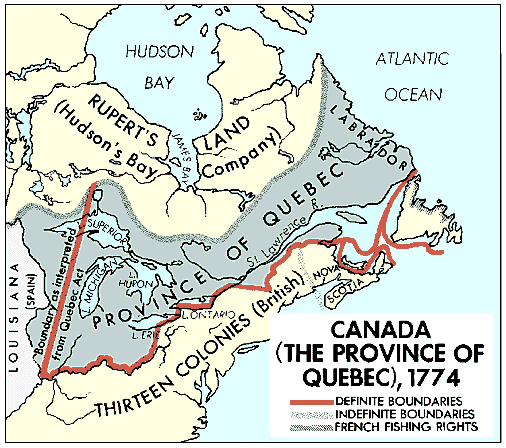 In 1774, Quebec Province stretched south of the Great Lakes to the Ohio and Mississippi Rivers.
 After the American Revolution ended British control of the area from the Allegany Mountains to the Mississippi, the new
United States of America moved its borders west.
After the American Revolution ended British control of the area from the Allegany Mountains to the Mississippi, the new
United States of America moved its borders west.
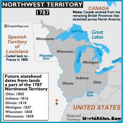 The area north of the Ohio River to the Mississippi River was administered as the Northwest Territory.
By 1817, the American Fur Company (headquartered in Astor, New York with a recruiting station in Montreal) employed nineteen-year-old Quebecois Noel LeVasseur (1799-1879)—along with friends Dominique Bray and Henri Boucher, and fifteen-year-old Makinaweon Gurdon Hubbard (1802-86).
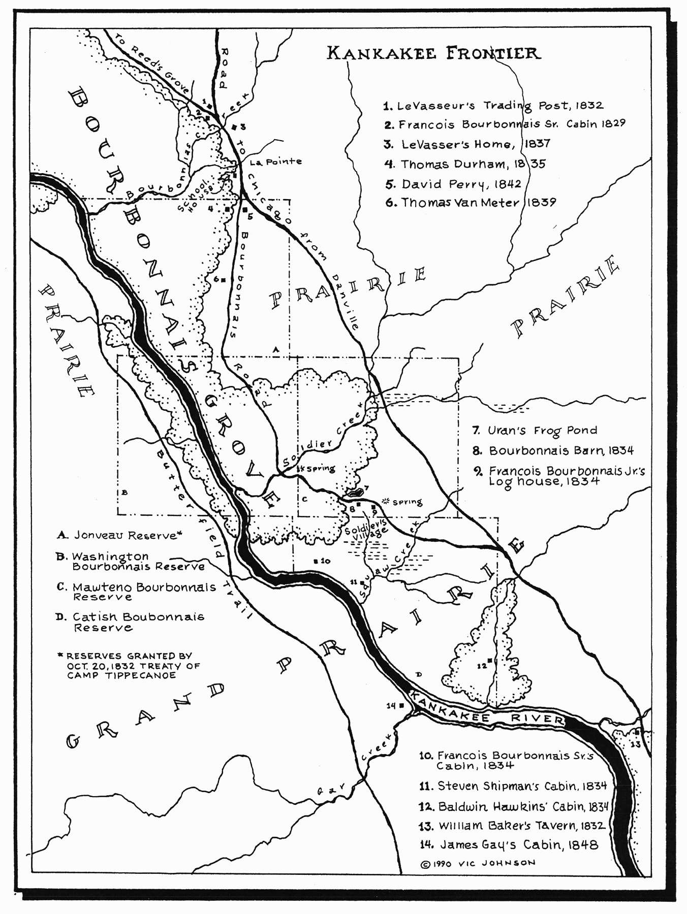 LeVasseur and Hubbard were both involved in purchasing native lands and opening the Chicago to Danville Road through the
Grand Prairie along the Kankakee River (now Route 102), and the Hubbard Trail which Illinois highway 1 now follows. By
the late 1820s and early 1830s, other French Canadians joined Noel LeVasseur in the settlement along the Kankakee. Due
to extensive recruitment during the 1830s and ‘40s in Quebec Province, Canada, by pioneer trader Noel LeVasseur, French
Canadians learned about the rich farm land along the Kankakee River.
LeVasseur and Hubbard were both involved in purchasing native lands and opening the Chicago to Danville Road through the
Grand Prairie along the Kankakee River (now Route 102), and the Hubbard Trail which Illinois highway 1 now follows. By
the late 1820s and early 1830s, other French Canadians joined Noel LeVasseur in the settlement along the Kankakee. Due
to extensive recruitment during the 1830s and ‘40s in Quebec Province, Canada, by pioneer trader Noel LeVasseur, French
Canadians learned about the rich farm land along the Kankakee River.